A unique new tool is being created in hopes of educating the public about riparian zones and proper land use.
“It’s to protect a multitude of things; fish, water quality, erosion, recreation and aesthetic values – why you’re here,” Cowichan Valley Regional District (CVRD) biologist Kate Lindsey told the Cowichan Lake and River Stewardship Committee, during their Thursday, March 10, meeting.
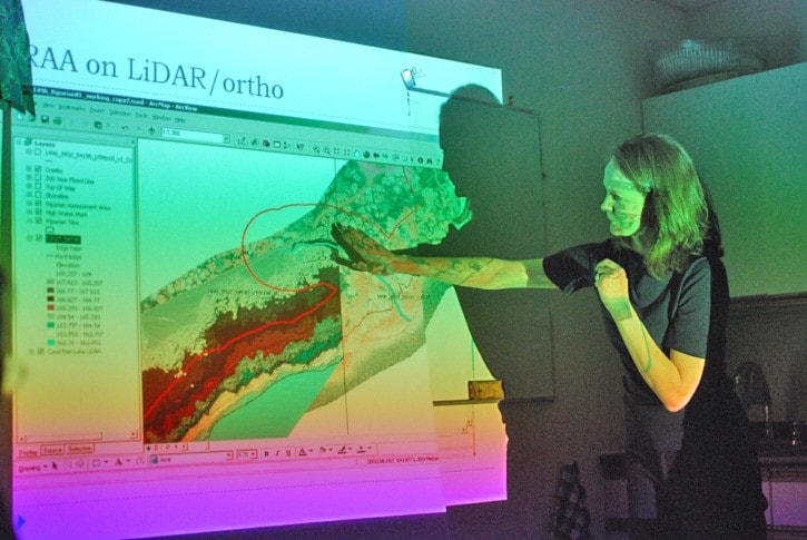
Lindsay, a qualified environmental professional, visited the stewards in order to share, and receive input, on the CVRD’s recent mapping of Cowichan Lake using LiDAR and orthoimagery, which is, basically, lasers from an airplane.
The mapping project includes a narrow strip of the shore along the lake, providing a detailed look at the various lines of elevation and distance, including the 200 year flood plain, the riparian zone, and the Streamside Protection and Enhancement Area (SPEA).
“It presents very accurate elevation date that we can partner with high quality orthoimagery,” Lindsey said. Orthoimagery is an accurate representation of the earth’s surface, such as what one could see using the website Google Earth.
“It makes it easier to know where these lines are.”
This new means of mapping can help property owners and prospective property owners, figure out exactly where their 30 metre riparian zone is located.
“This will provide a chance to have a consistent approach,” Lindsey said.
The riparian zone is an area in which the land must be left in its natural state, in order to prevent erosion of the shoreline, in addition to other environmental dangers.
The SPEA is similar to a riparian zone, Lindsey said, but adds more variance to the equation. Whereas riparian zones are consistent around water sources, SPEAs can vary.
The protected area around a stream, as an example, can vary, depending on the width of the stream.
The Cowichan Lake area’s SPEA is still being determined by the CVRD, with greater detail to be put into this new mapping project as up to date information becomes available.
Although the new LiDAR mapping project has been partially complete, Lindsey cautioned that her meeting with the stewards was a preliminary one, and that the updated Cowichan Lake map will not open to the public until it’s been more finely tuned.
“It’s in that transition period,” she said.
Once complete, Lindsey said that the LiDAR mapping could become a useful tool for the public, serving to educate them as to what land use designations are, and where things such as the 200-year flood plain are, in relation to their properties.
For now, the CVRD is also looking to public consultation, which is large part of why Lindsey met with the stewards.
“We’d like to work with those who’d like to work with us,” she said.
The main input she received from the stewards meeting was that the LiDAR mapping would be an excellent tool for public education purposes.
The stewards hope to use the LiDAR mapping during future meetings they have planned with local real estate agents.
The maps will also be a particularly important tool for their future goal of informing the public as to riparian zone regulations in place at Cowichan Lake.
So far, the LiDAR mapping has only been done at Cowichan Lake, and not the Cowichan River.