Retreads have completed hikes up Stoney Mountain near Genoa Bay, up Mount Finlayson near Victoria, a hike around the hidden trail at the top of Mount Prevost, and a nearby hike down the Cowichan River from Trestle 66.
We approached Stoney Mountain from Genoa Bay Road; followed the new road that goes up the hill for about 300 metres and then moved onto the trail that leads on up and across to the first viewpoint. From here we could see down past Arbutus Ridge to the approach to Victoria airport and across to Saltspring Island. We rested briefly and then went back down into the valley and climbed out onto another point high above the Maple Bay channel. Here, as we settled for a lunch break, we watched a huge log boom being towed up the channel by what appeared to be a tiny tug boat.
A week later we carpooled down to Goldstream Park. The keener and fitter part of the group headed up the steady climb to the top of Mount Finlayson where we gained some great views across Victoria to the San Juan Islands and the coastal mountains of Washington State. A tough hike up the side of the mountain but a rewarding view at the top.
The rest of the group headed through a culvert under the highway and up the hill that leads to a closed mine. They went up and up and then levelled out and headed along the ridge in the direction of Victoria. A few ups and downs and they eventually came through the campground and down a set of steps to the Goldstream waterfalls. This group was left wondering if they had actually taken an easier hike.
The next week, while parked at the base of Mount Prevost, assembling our numbers, an individual stopped and advised us against hiking up the mountain that day since there would be numerous mountain bikers careening down the trail at high speeds. We assured him that we would be at no risk since we intended to drive to the top of the mountain and hike along a loop trail near the summit. The Hidden Peak Loop Trail starts on the back side (north side) of Mount Prevost and winds through the forest, leading us to our first view — a rocky bluff where we could gaze across to Mount Benton and the Chemainus River valley.
After another lovely walk through the woods, we ventured out onto another open rocky bluff where we could look westward at the Cowichan Valley far below us.
Not much further along, we clambered up onto one of the two bare outcrops you can see if you look up at Mount Prevost from Highway 18 near the Averill Creek turn-off. This one is called ‘hang-gliders bluff’ and features a wind sock and some scary vertical drops that hang-gliders use to launch themselves off the mountain.
The vistas from this vantage point are amazing — you can see all of Duncan far below and look out over the ocean towards the mainland and partially snow-covered Mount Baker. It was great walking along the edge of the mountain with such stunning views to our right. But we still had one more peak to conquer and one more vista to enjoy.
This one involved some scrambling over boulders and a short, but steep ascent to the last rocky prominence where we enjoyed our lunch and the panoramic view. After our break, we followed along to the impressive cairn erected to commemorate those lost in the First World War, Second World War and other conflicts. Once you know of it, you can see this cairn from the highway.
We then completed our loop by heading downhill some distance to the place where we had left our vehicles.
Nineteen of us started the Cowichan Valley hike from the Maria Canyon or Trestle 66 parking lot. That trail took us down the edge of the river for five kilometres with stops at different view points and a first lunch stop on fallen logs where the river has flattened out and is flowing gently around a broad curve. On again for a further two kilometres through forest where maple tends to dominate and the ferns are robust and healthy looking and then up a little rise to meet the Trans Canada Trail or old railway grade coming from Shawnigan Lake.
Another lunch break, this time on a bridge across a creek that is bone dry. A constant discussion on this hike was how low the river is and how dry the forest is.
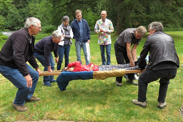
Because we are often out in bush where communications with the outside world can be a challenge, a number of us came together for a few hours to work out mishap strategies. We discussed roles we would play, risks we could face and steps we might take to make an injured member comfortable and help them to get out to the vehicles. This included the use of temporary slings, walking people with injured and strapped legs and even a procedure to make a stretcher using poles and jackets. This session was most helpful in working out strategies and indicating that within the group are many talented people that bring different experience and abilities to our hiking club.
with contributions from
Willa Suntjens