Retreads recently did two nearby seasonal hikes, one down the Cowichan River Loop with the river in full flow and some gallant salmon making their way up; and the other up old logging roads and with a scramble down the river side to view the Robertson River falls in full flow.
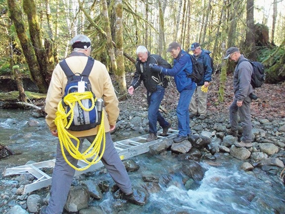
The Robertson hike started with a bit of excitement as we were helped one by one across a creek on a makeshift bridge created by laying out an extension ladder. All made the crossing with help and egging on. We then followed the river on an old logging road that runs beside it. Robertson River was unbelievably crystal clear and we had hoped to see some fish but none were spotted even by those with updated eye lenses.
After we left the forest, the broom growing alongside the road was sparkling with frost adding a special effect to an already beautiful day. We then started up a long incline through an old clear-cut allowing wonderful views across the valley. We could hear the falls before we turned off the road to a rough trail that follows a ridge to an overlook at the top. We stayed on this mossy verge above the falls for an early lunch then half of the group took a steep, slippery trail down into the gully that leads to the base of this magnificent 30 metre falls. Cliff, our trusty leader had brought a heavy rope which he tied to a tree near the bottom so we could safely clamber down to, and over a small stream draining into the river at the base of the falls.
The falls were fuller and more spectacular than we have ever seen them, making our challenging descent well worthwhile. While we were making this short side trip, the rest of the group soaked up some warm sunshine. Together again, we walked the 4 km back to our cars, enjoying the expansive views along the way.
A week earlier 17 of us parked at the end of Mayo Road, crossed the logging bridge and set out along the Cowichan River Loop. After some time we climbed a short steep hill and paused at a viewpoint high above the river where it moves around a sharp bend with a gravel bank. That bank has been prone to erosion, but is now somewhat stable. Here we witnessed much gull and occasional eagle activity as they chased pieces of salmon.
Further along, opposite the group campground we were right down by the river’s edge but unable to venture out onto rocky ridges that were covered by the high river flow. We did see a few pretty tired salmon resting in a shallow pool at the edge of the river but the river was a bit cloudy so we did not see them swimming up.
On down stream over a creek with a neat but slippery bridge up over some hills and then great joy as trestle 66 came into view. As we trudged along, skipping over but not tripping on tree roots I eavesdropped on fascinating discussions from the women behind me. The one topic that stuck in my mind was the one where “you could scrub your skin with a particular kind of brush and it came out as smooth as a baby’s bum.”
After a view down into the river from the trestle above, we continued on along trails high above the north side of the river. At one point the trail, above a bend in the river, took us out for a few metres on the Trans Canada Trail, and then back onto the river trail that gradually descends until we reach the group camp which has a shelter with rows of picnic tables.
At lunch we were not alone. There was a Duncan party occupying one table and as we sat another group passed along the trail. It was good to know that these park trails were being well used. After a pleasant lunch break sitting at tables, which is not our norm, we headed out to complete the last quarter of this loop. Mostly we travelled along reasonably level trails under huge big leaf maple trees. Sometimes beside side creeks flowing into the river and sometimes on low ridges obviously formed by earlier river changes.
Then the Mayo Road forest bridge came into view and we soon completed the ever popular 8 km river loop. We also made a brief stop at Skutz Falls with a swirling torrent of water. A fascinating view in heavy flows.